
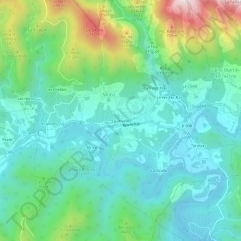
La Trivalle topographic map
Interactive map
Click on the map to display elevation.
About this map
Name: La Trivalle topographic map, elevation, terrain.
Average elevation: 297 m
Minimum elevation: 112 m
Maximum elevation: 846 m
Other topographic maps
Click on a map to view its topography, its elevation and its terrain.
Gorges d’Héric
France > Occitanie > Hérault > Mons
Gorges d’Héric, Mons, Béziers, Hérault, Occitanie, France métropolitaine, 34390, France
Average elevation: 573 m
Le Verdier-Haut
France > Occitanie > Hérault > Mons
Le Verdier-Haut, Mons, Béziers, Hérault, Occitanie, France métropolitaine, 34390, France
Average elevation: 363 m
Les Pradals
France > Occitanie > Hérault > Mons
Les Pradals, Mons, Béziers, Hérault, Occitanie, France métropolitaine, 34390, France
Average elevation: 357 m