Geolocate

Town of Oyster Bay topographic map

Interactive map

Click on the map to display elevation.

About this map

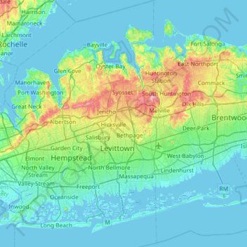
Name: Town of Oyster Bay topographic map, elevation, terrain.

Location: Town of Oyster Bay, Nassau County, New York, United States (40.54513 -73.66199 40.96420 -73.42314)

Average elevation: 19 m

Minimum elevation: -4 m

Maximum elevation: 111 m

Other topographic maps

Click on a map to view its topography, its elevation and its terrain.

Village of Garden City

United States > New York > Nassau County

Village of Garden City, Town of Hempstead, Nassau County, New York, 11530, United States

Average elevation: 27 m

Village of Valley Stream

United States > New York > Nassau County

Village of Valley Stream, Town of Hempstead, Nassau County, New York, 11580, United States

Average elevation: 7 m

Woodbury

United States > New York > Nassau County

Woodbury, Town of Oyster Bay, Nassau County, New York, 11797, United States

Average elevation: 70 m

Massapequa

United States > New York > Nassau County > Massapequa

Massapequa, Town of Oyster Bay, Nassau County, New York, United States

Average elevation: 6 m