
Pilibhit topographic map
Interactive map
Click on the map to display elevation.
About this map
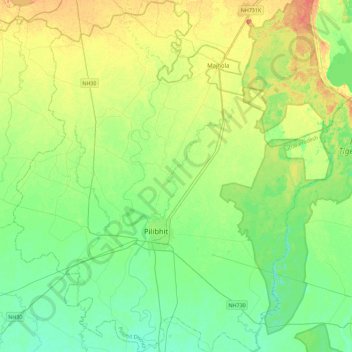
Name: Pilibhit topographic map, elevation, terrain.
Location: Pilibhit, Pilibhit District, Uttar Pradesh, India (28.49317 79.62278 28.88868 80.03184)
Average elevation: 190 m
Minimum elevation: 174 m
Maximum elevation: 220 m
Other topographic maps
Click on a map to view its topography, its elevation and its terrain.
Dalla
India > Uttar Pradesh > Dalla
Dalla, Robertsganj, Sonbhadra, Uttar Pradesh, India
Average elevation: 215 m
Gange
Gange, Ghāzīpur, Ghazipur, Uttar Pradesh, 249304, India
Average elevation: 1,626 m