
Thank you for supporting this site ❤️
Make a donation
Make a donation
Jubia topographic map
Click on the map to display elevation.
Thank you for supporting this site ❤️
Make a donation
Make a donation
About this map
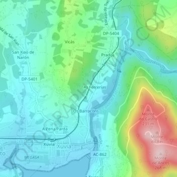
Name: Jubia topographic map, elevation, terrain.
Location: Jubia, Narón, Ferrol, La Coruña, Galicia, España (43.51227 -8.16946 43.53760 -8.14294)
Average elevation: 64 m
Minimum elevation: -1 m
Maximum elevation: 257 m
Thank you for supporting this site ❤️
Make a donation
Make a donation
Other topographic maps
Click on a map to view its topography, its elevation and its terrain.