
Aichach topographic map
Interactive map
Click on the map to display elevation.
About this map
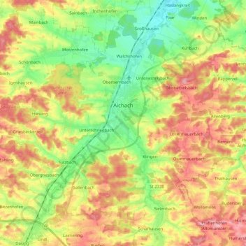
Name: Aichach topographic map, elevation, terrain.
Location: Aichach, Landkreis Aichach-Friedberg, Bavaria, 86551, Germany (48.39636 11.01204 48.50236 11.21434)
Average elevation: 482 m
Minimum elevation: 427 m
Maximum elevation: 543 m
Other topographic maps
Click on a map to view its topography, its elevation and its terrain.
Unterschneitbach
Unterschneitbach, Aichach, Landkreis Aichach-Friedberg, Bavaria, Germany
Average elevation: 475 m