
Palmerston North topographic map
Interactive map
Click on the map to display elevation.
Palmerston North
Although the land Palmerston North is situated on is bounded by the lofty Ruahine and Tararua ranges in the east and south respectively, the city has a predominantly flat appearance. The occasional rise in elevation occurs further away from the river and is especially pronounced in the north and northeast, and also on the south side of the river. The typical urban area elevation ranges between 20–40 metres (65–130 ft) above sea level.
About this map
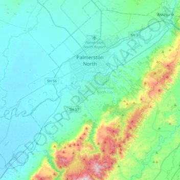
Name: Palmerston North topographic map, elevation, terrain.
Location: Palmerston North, Manawatū-Whanganui, New Zealand (-40.52969 175.49733 -40.26808 175.79059)
Average elevation: 133 m
Minimum elevation: 4 m
Maximum elevation: 756 m
Manawatu-Whanganui trails, hiking, mountain biking, running and outdoor activities
Other topographic maps
Click on a map to view its topography, its elevation and its terrain.
Waiouru
New Zealand > Manawatu-Whanganui > Ruapehu District
Because of its high altitude and close proximity to Mt Ruapehu, Waiouru's climate is cold throughout the year, unlike other North Island centres, and particularly cold when the wind blows from the mountain. The Desert Road is regularly closed in winter owing to heavy snowfalls. Waiouru's climate can be…
Average elevation: 817 m
Kitchener Park
New Zealand > Manawatu-Whanganui > Manawatū District > Feilding
Average elevation: 63 m
Pohangina
New Zealand > Manawatu-Whanganui > Manawatū District
Pohangina is located along the foot of the Ruahine Range, and is primarily farming land. Farming varies from sheep and cattle to crops of maize and 'chow'. The farmland was originally ancient native forest. Rimu and northern rātā grew above 1000 feet, with kamahi, kaikawaka and pink pine growing at higher…
Average elevation: 190 m
Mount Tongariro
New Zealand > Manawatu-Whanganui > Ruapehu District
The high altitude and severe alpine climate between March and October allow snowfall in the winter (there are commercial ski-fields at neighbouring Mount Ruapehu) and rain can freeze, causing verglas; in contrast in the mid to late summer, the mountains can be bare apart from remnant patches of snow in…
Average elevation: 1,675 m
Waiouru
New Zealand > Manawatu-Whanganui > Ruapehu District
Because of its high altitude and close proximity to Mt Ruapehu, Waiouru's climate is cold throughout the year, unlike other North Island centres, and particularly cold when the wind blows from the mountain. The Desert Road is regularly closed in winter owing to heavy snowfalls. Waiouru's climate can be…
Average elevation: 817 m
Mount Ruapehu
New Zealand > Manawatu-Whanganui > Ruapehu District
Ruapehu has a polar tundra climate (Köppen: ET) on the upper slopes, with average temperatures ranging from −4–15 °C in summer and −7–7 °C in winter, depending on elevation and cloudiness. On the lower slopes, Ruapehu has a subpolar oceanic climate (Köppen: Cfc).
Average elevation: 2,474 m