
Linwood-Central-Heathcote Community topographic map
Interactive map
Click on the map to display elevation.
About this map
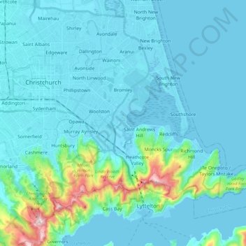
Name: Linwood-Central-Heathcote Community topographic map, elevation, terrain.
Average elevation: 55 m
Minimum elevation: -3 m
Maximum elevation: 500 m
Christchurch City trails, hiking, mountain biking, running and outdoor activities
Other topographic maps
Click on a map to view its topography, its elevation and its terrain.
Port hills
New Zealand > Canterbury > Christchurch City > Linwood-Central-Heathcote Community
Average elevation: 246 m