
Make a donation
Bogor topographic map
Click on the map to display elevation.
Make a donation
Bogor
The city is situated in the western part of Java island, about 53 km south of the capital Jakarta and 85 km northwest of Bandung, the administrative center of West Java Province. Bogor spreads over a basin near volcanoes Salak, which peaks at about 12 km south, and Mount Gede whose top is 22–25 km south-east of the city. The average elevation is 265 meters, maximum 330 m, and minimum 190 meters above sea level. The terrain is rather uneven: 17.64 km2 of its area has slopes of 0–2°, 80.9 km2 from 2° to 15°, 11 km2 between 15° and 25°, 7.65 km2 from 25° to 40° and 1.20 km2 over 40°; the northern part is relatively flat and the southern part is more hilly.
Make a donation
About this map
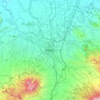
Name: Bogor topographic map, elevation, terrain.
Location: Bogor, West Java, 16121, Indonesia (-6.75630 106.63724 -6.43630 106.95724)
Average elevation: 442 m
Minimum elevation: 47 m
Maximum elevation: 2,397 m
Make a donation
Other topographic maps
Click on a map to view its topography, its elevation and its terrain.
Cisarua
Cisarua is a location and district in the Bogor Regency, located in the province of West Java, with a population of 127,096 in 2020. The district is known for its mild climate, tea fields, and extensive views, being located in a rather high altitude.
Average elevation: 1,310 m
Make a donation
Make a donation
Make a donation
Make a donation
Gunung Guntur Nature Recreation Park
Indonesia > West Java > Garut > Sukaraja
Average elevation: 1,336 m
Make a donation
Make a donation
Make a donation
Dusun Gunung Medang, Desa Kawitan, Kec. Salopa, Kab. Tasikmalaya
Indonesia > West Java > Tasikmalaya
Average elevation: 498 m
Make a donation
Make a donation
Make a donation
Make a donation
Make a donation
Make a donation
Make a donation
Make a donation
Make a donation
Pangandaran Beach
Indonesia > West Java > Pangandaran > Desa Pagandaran > Pangandaran
Average elevation: 4 m
Make a donation
Make a donation
Make a donation
Make a donation
Make a donation
Make a donation
Make a donation
Make a donation
Make a donation