
Riverside topographic map
Interactive map
Click on the map to display elevation.
About this map
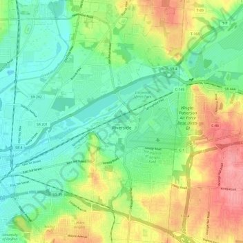
Name: Riverside topographic map, elevation, terrain.
Location: Riverside, Montgomery County, Ohio, 45437, United States (39.73614 -84.16464 39.82704 -84.09492)
Average elevation: 256 m
Minimum elevation: 222 m
Maximum elevation: 315 m
Other topographic maps
Click on a map to view its topography, its elevation and its terrain.
Dayton
United States > Ohio > Montgomery County
Dayton, Montgomery County, Ohio, United States
Average elevation: 270 m
Boone Island (historical)
United States > Ohio > Montgomery County > West Carrollton
Boone Island (historical), West Carrollton, Montgomery County, Ohio, 45449, United States
Average elevation: 276 m
Shiloh
United States > Ohio > Montgomery County > Shiloh
Shiloh, Montgomery County, Ohio, United States
Average elevation: 262 m
Clement
United States > Ohio > Montgomery County > Riverside
Clement, Riverside, Montgomery County, Ohio, 45432, United States
Average elevation: 275 m
Kettering
United States > Ohio > Montgomery County
Kettering, Montgomery County, Ohio, United States
Average elevation: 275 m
Miamisburg Community Park
United States > Ohio > Montgomery County > Miamisburg
Miamisburg Community Park, Miamisburg, Miami Township, Montgomery County, Ohio, United States
Average elevation: 241 m
Berkley Heights
United States > Ohio > Montgomery County > Kettering
Berkley Heights, Kettering, Montgomery County, Ohio, 45439, United States
Average elevation: 253 m
Dayton
United States > Ohio > Montgomery County > Dayton
Dayton, Montgomery County, Ohio, 45423, United States
Average elevation: 270 m
Miamisburg
United States > Ohio > Montgomery County
Miamisburg, Montgomery County, Ohio, 45342, United States
Average elevation: 247 m
Clayton
United States > Ohio > Montgomery County
Clayton, Montgomery County, Ohio, 45315, United States
Average elevation: 300 m
Patterson
United States > Ohio > Montgomery County > Dayton
Patterson, Dayton, Montgomery County, Ohio, 45408, United States
Average elevation: 233 m
Farmersville
United States > Ohio > Montgomery County
Farmersville, Montgomery County, Ohio, 45325, United States
Average elevation: 259 m
West Carrollton
United States > Ohio > Montgomery County
West Carrollton, Montgomery County, Ohio, 45449, United States
Average elevation: 238 m
Washington Township
United States > Ohio > Montgomery County
Washington Township, Montgomery County, Ohio, United States
Average elevation: 285 m
Residence Park
United States > Ohio > Montgomery County > Dayton
Residence Park, Dayton, Montgomery County, Ohio, 45428, United States
Average elevation: 266 m
Oakwood
United States > Ohio > Montgomery County
Oakwood, Montgomery County, Ohio, 45419, United States
Average elevation: 280 m
West Side
United States > Ohio > Montgomery County > Dayton
West Side, Dayton, Montgomery County, Ohio, 45407, United States
Average elevation: 232 m
Trotwood
United States > Ohio > Montgomery County
Trotwood, Montgomery County, Ohio, United States
Average elevation: 275 m
Englewood
United States > Ohio > Montgomery County
Englewood, Montgomery County, Ohio, 45322, United States
Average elevation: 282 m
Greenmont
United States > Ohio > Montgomery County > Kettering
Greenmont, Kettering, Montgomery County, Ohio, 45420, United States
Average elevation: 282 m
Pasadena
United States > Ohio > Montgomery County > Kettering
Pasadena, Kettering, Montgomery County, Ohio, 45429, United States
Average elevation: 299 m
Miami Township
United States > Ohio > Montgomery County
Miami Township, Montgomery County, Ohio, United States
Average elevation: 272 m
Centerville
United States > Ohio > Montgomery County > Centerville > Centerville
Centerville, Montgomery County, Ohio, 45459, United States
Average elevation: 288 m
Miami Shores
United States > Ohio > Montgomery County > Moraine
Miami Shores, Moraine, Montgomery County, Ohio, 45439, United States
Average elevation: 232 m
Miamisburg
United States > Ohio > Montgomery County > Miamisburg > Miamisburg
Miamisburg, Montgomery County, Ohio, 45342, United States
Average elevation: 245 m
Crown Point
United States > Ohio > Montgomery County > Dayton > Crown Point
Crown Point, Dayton, Montgomery County, Ohio, 45428, United States
Average elevation: 273 m
New Lebanon
United States > Ohio > Montgomery County > New Lebanon
New Lebanon, Montgomery County, Ohio, United States
Average elevation: 278 m
Oakdale
United States > Ohio > Montgomery County > Kettering
Oakdale, Kettering, Montgomery County, Ohio, 45429, United States
Average elevation: 297 m
Centerville
United States > Ohio > Montgomery County
Centerville, Montgomery County, Ohio, United States
Average elevation: 287 m
Germantown
United States > Ohio > Montgomery County
Germantown, Montgomery County, Ohio, 45327, United States
Average elevation: 238 m
Vandalia
United States > Ohio > Montgomery County
Vandalia, Montgomery County, Ohio, 45377, United States
Average elevation: 280 m
Huber Heights
United States > Ohio > Montgomery County
Huber Heights, Montgomery County, Ohio, 45424, United States
Average elevation: 274 m