
Town of Knox topographic map
Interactive map
Click on the map to display elevation.
About this map
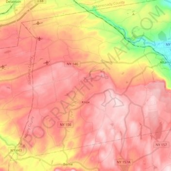
Name: Town of Knox topographic map, elevation, terrain.
Location: Town of Knox, Albany County, New York, United States (42.62781 -74.19184 42.73916 -74.02046)
Average elevation: 344 m
Minimum elevation: 117 m
Maximum elevation: 470 m
Other topographic maps
Click on a map to view its topography, its elevation and its terrain.
City of Albany
United States > New York > Albany County
City of Albany, Albany County, New York, United States
Average elevation: 68 m
Town of Coeymans
United States > New York > Albany County
Town of Coeymans, Albany County, New York, United States
Average elevation: 81 m
Thompsons Lake
United States > New York > Albany County > Town of Berne
Thompsons Lake, Town of Berne, Albany County, New York, 12059, United States
Average elevation: 408 m
Town of Rensselaerville
United States > New York > Albany County
Town of Rensselaerville, Albany County, New York, United States
Average elevation: 413 m
Village of Altamont
United States > New York > Albany County > Town of Guilderland
Village of Altamont, Town of Guilderland, Albany County, New York, United States
Average elevation: 158 m
Westmere
United States > New York > Albany County > Town of Guilderland
Westmere, Town of Guilderland, Albany County, New York, United States
Average elevation: 79 m
Fort Hunter
United States > New York > Albany County > Town of Guilderland
Fort Hunter, Town of Guilderland, Albany County, New York, 12303, United States
Average elevation: 99 m
Boght Corners
United States > New York > Albany County > Town of Colonie
Boght Corners, Town of Colonie, Albany County, New York, 12047, United States
Average elevation: 84 m
East Berne
United States > New York > Albany County > Town of Berne
East Berne, Town of Berne, Albany County, New York, 12059, United States
Average elevation: 410 m
Cedar Hill
United States > New York > Albany County > Town of Bethlehem
Cedar Hill, Town of Bethlehem, Albany County, New York, 12158, United States
Average elevation: 29 m
North Bethlehem
United States > New York > Albany County > Town of Guilderland
North Bethlehem, Town of Guilderland, Albany County, New York, 12203, United States
Average elevation: 65 m
Coeymans Hollow
United States > New York > Albany County > Town of Coeymans
Coeymans Hollow, Town of Coeymans, Albany County, New York, 12046, United States
Average elevation: 187 m
Wemple
United States > New York > Albany County > Town of Bethlehem
Wemple, Town of Bethlehem, Albany County, New York, 12077, United States
Average elevation: 32 m
West Township
United States > New York > Albany County > Town of Knox
West Township, Town of Knox, Albany County, New York, 12107, United States
Average elevation: 388 m
West Berne
United States > New York > Albany County > Town of Knox
West Berne, Town of Knox, Albany County, New York, 12023, United States
Average elevation: 322 m
Beckers Corners
United States > New York > Albany County > Town of Bethlehem
Beckers Corners, Town of Bethlehem, Albany County, New York, 12158, United States
Average elevation: 49 m
Bethlehem Heights
United States > New York > Albany County > Town of Bethlehem
Bethlehem Heights, Town of Bethlehem, Albany County, New York, 12161, United States
Average elevation: 53 m
South Albany
United States > New York > Albany County > Town of Bethlehem
South Albany, Town of Bethlehem, Albany County, New York, 12161, United States
Average elevation: 64 m
Meadowdale
United States > New York > Albany County > Town of Guilderland
Meadowdale, Town of Guilderland, Albany County, New York, 12085, United States
Average elevation: 115 m
Wolf Hill
United States > New York > Albany County > Town of New Scotland
Wolf Hill, Town of New Scotland, Albany County, New York, 12041, United States
Average elevation: 385 m
Unionville
United States > New York > Albany County > Town of New Scotland
Unionville, Town of New Scotland, Albany County, New York, 12067, United States
Average elevation: 88 m
Tarrytown
United States > New York > Albany County > Town of New Scotland
Tarrytown, Town of New Scotland, Albany County, New York, 12041, United States
Average elevation: 222 m
Potter Hollow
United States > New York > Albany County > Town of Rensselaerville
Potter Hollow, Preston-Potter Hollow, Town of Rensselaerville, Albany County, New York, 12469, United States
Average elevation: 346 m
Roessleville
United States > New York > Albany County
Roessleville, Town of Colonie, Albany County, New York, 12005, United States
Average elevation: 82 m
Reidsville
United States > New York > Albany County > Town of Berne
Reidsville, Town of Berne, Albany County, New York, United States
Average elevation: 431 m
South Berne
United States > New York > Albany County > Town of Berne
South Berne, Town of Berne, Albany County, New York, United States
Average elevation: 445 m
Normansville
United States > New York > Albany County > City of Albany
Normansville, City of Albany, Albany County, New York, 12209, United States
Average elevation: 56 m
Houcks Corners
United States > New York > Albany County > Town of Bethlehem
Houcks Corners, Town of Bethlehem, Albany County, New York, 12054, United States
Average elevation: 59 m
Spawn Hollow
United States > New York > Albany County > Town of Bethlehem
Spawn Hollow, Town of Bethlehem, Albany County, New York, 12607, United States
Average elevation: 94 m
Slingerlands
United States > New York > Albany County > Town of Bethlehem
Slingerlands, Town of Bethlehem, Albany County, New York, 12159, United States
Average elevation: 65 m
South Bethlehem
United States > New York > Albany County > Town of Bethlehem
South Bethlehem, Town of Bethlehem, Albany County, New York, 12161, United States
Average elevation: 72 m
Aquetuck
United States > New York > Albany County > Town of Coeymans
Aquetuck, Town of Coeymans, Albany County, New York, 12143, United States
Average elevation: 110 m
Town of Green Island
United States > New York > Albany County
Town of Green Island, Albany County, New York, 12183, United States
Average elevation: 19 m
Dunnsville
United States > New York > Albany County > Town of Guilderland
Dunnsville, Town of Guilderland, Albany County, New York, 12009, United States
Average elevation: 130 m
Fullers
United States > New York > Albany County > Town of Guilderland
Fullers, Town of Guilderland, Albany County, New York, 12085, United States
Average elevation: 90 m
Hartmans Corners
United States > New York > Albany County > Town of Guilderland
Hartmans Corners, Town of Guilderland, Albany County, New York, 12084, United States
Average elevation: 81 m
East Township
United States > New York > Albany County > Town of Knox
East Township, Town of Knox, Albany County, New York, 12107, United States
Average elevation: 332 m
Thompson's Lake State Park
United States > New York > Albany County > Town of Knox
Thompson's Lake State Park, Town of Knox, Albany County, New York, United States
Average elevation: 410 m
Clarksville
United States > New York > Albany County > Town of New Scotland
Clarksville, Town of New Scotland, Albany County, New York, 12041, United States
Average elevation: 243 m
Cooksburg
United States > New York > Albany County > Town of Rensselaerville
Cooksburg, Preston-Potter Hollow, Town of Rensselaerville, Albany County, New York, 12422, United States
Average elevation: 332 m
Medusa
United States > New York > Albany County > Town of Rensselaerville
Medusa, Town of Rensselaerville, Albany County, New York, 12120, United States
Average elevation: 297 m
South Westerlo
United States > New York > Albany County > Town of Westerlo
South Westerlo, Town of Westerlo, Albany County, New York, 12083, United States
Average elevation: 291 m
Lambs Corner
United States > New York > Albany County > Town of Westerlo
Lambs Corner, Town of Westerlo, Albany County, New York, 12083, United States
Average elevation: 322 m
Loudonville
United States > New York > Albany County
Loudonville, Town of Colonie, Albany County, New York, United States
Average elevation: 82 m
Village of Menands
United States > New York > Albany County > Town of Colonie
Village of Menands, Town of Colonie, Albany County, New York, 12204, United States
Average elevation: 34 m
Delmar
United States > New York > Albany County > Town of Bethlehem
Delmar, Town of Bethlehem, Albany County, New York, 12054, United States
Average elevation: 61 m
West Albany
United States > New York > Albany County > City of Albany
West Albany, City of Albany, Albany County, New York, 12111, United States
Average elevation: 78 m
Dunes
United States > New York > Albany County > Westmere
Dunes, Westmere, Town of Guilderland, Albany County, New York, 12203, United States
Average elevation: 75 m
New Salem
United States > New York > Albany County > Town of New Scotland
New Salem, Town of New Scotland, Albany County, New York, 12186, United States
Average elevation: 212 m
Guilderland Center
United States > New York > Albany County > Town of Guilderland
Guilderland Center, Town of Guilderland, Albany County, New York, 12085, United States
Average elevation: 96 m