
Make a donation
Worsbrough topographic map
Click on the map to display elevation.
Make a donation
Worsbrough
On High Street, Worsbrough Dale. The east elevation bears the inscriptions "AD 1903" and "Ebenezer Wesleyan Reform". There are also foundation stones either side of the doorway inscribed with "EBENEZER CHAPEL 1854". This suggests that the chapel was built in 1854 and extended upwards in 1903.
Make a donation
About this map
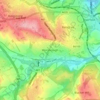
Name: Worsbrough topographic map, elevation, terrain.
Average elevation: 98 m
Minimum elevation: 37 m
Maximum elevation: 172 m
Make a donation
Other topographic maps
Click on a map to view its topography, its elevation and its terrain.
High Hoyland
United Kingdom > England > Barnsley
High Hoyland is a village and civil parish in the Metropolitan Borough of Barnsley in South Yorkshire, England, on the border with West Yorkshire. It lies to the west of Kexbrough, and is located at approximately 53°35′10″N 1°35′30″W / 53.58611°N 1.59167°W / 53.58611; -1.59167, at an…
Average elevation: 139 m
Shafton
United Kingdom > England > Barnsley
Shafton lies to the north of Shafton Two Gates, on the road to Ryhill. It is located at approximately 53° 35' 10" North, 1° 24' West, at an elevation of around 262 feet (80 m) above sea level. Sceptun in the Domesday Book of 1086 then later in c. 1160 Scaftona meaning a farmstead marked by a pole, or made…
Average elevation: 65 m
Make a donation
Make a donation