
Make a donation
Long Beach topographic map
Click on the map to display elevation.
Make a donation
About this map
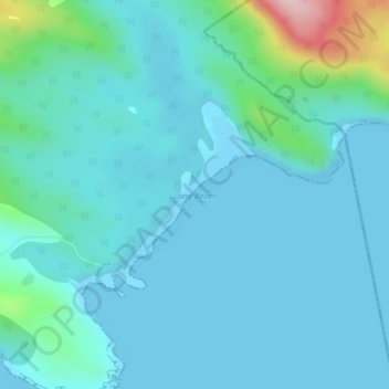
Name: Long Beach topographic map, elevation, terrain.
Average elevation: 36 m
Minimum elevation: -1 m
Maximum elevation: 265 m
Southland District trails, hiking, mountain biking, running and outdoor activities
Make a donation
Other topographic maps
Click on a map to view its topography, its elevation and its terrain.
Longbush
New Zealand > Southland > Southland District > Waihopai Toetoe Community
Average elevation: 32 m
Wyndham
New Zealand > Southland > Southland District > Waihopai Toetoe Community
Average elevation: 32 m
Fortrose
New Zealand > Southland > Southland District > Waihopai Toetoe Community
Average elevation: 12 m
Rakahouka
New Zealand > Southland > Southland District > Waihopai Toetoe Community
Average elevation: 38 m
Make a donation
Redan
New Zealand > Southland > Southland District > Waihopai Toetoe Community
Average elevation: 109 m
Tokanui
New Zealand > Southland > Southland District > Waihopai Toetoe Community
Average elevation: 85 m
Slope Point
New Zealand > Southland > Southland District > Waihopai Toetoe Community > Slope Point
Average elevation: 36 m