
Thank you for supporting this site ❤️
Make a donation
Make a donation
Etwatwa topographic map
Click on the map to display elevation.
Thank you for supporting this site ❤️
Make a donation
Make a donation
About this map
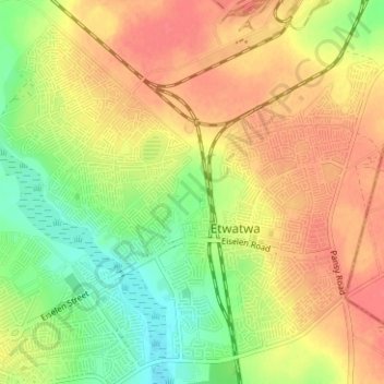
Name: Etwatwa topographic map, elevation, terrain.
Average elevation: 1,611 m
Minimum elevation: 1,581 m
Maximum elevation: 1,633 m
Thank you for supporting this site ❤️
Make a donation
Make a donation
Other topographic maps
Click on a map to view its topography, its elevation and its terrain.
Tembisa
South Africa > Gauteng > City of Ekurhuleni Metropolitan Municipality > Tembisa
Average elevation: 1,594 m