
Thank you for supporting this site ❤️
Make a donation
Make a donation
Sparks topographic map
Click on the map to display elevation.
Thank you for supporting this site ❤️
Make a donation
Make a donation
About this map
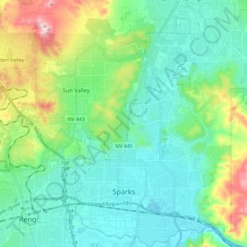
Name: Sparks topographic map, elevation, terrain.
Location: Sparks, Washoe County, Nevada, United States (39.51194 -119.78114 39.63835 -119.64975)
Average elevation: 1,438 m
Minimum elevation: 1,331 m
Maximum elevation: 1,784 m
Thank you for supporting this site ❤️
Make a donation
Make a donation
Other topographic maps
Click on a map to view its topography, its elevation and its terrain.
Gerlach
United States > Nevada > Washoe County
According to the United States Census Bureau, the Gerlach CDP has a total area of 3.1 square miles (8.0 km2), all land. Its elevation is 3,944 ft (1,202 m). Gerlach is approximately 100 miles (160 km) north of Reno, Nevada.
Average elevation: 1,208 m
Thank you for supporting this site ❤️
Make a donation
Make a donation
Thank you for supporting this site ❤️
Make a donation
Make a donation
Thank you for supporting this site ❤️
Make a donation
Make a donation
Thank you for supporting this site ❤️
Make a donation
Make a donation
Thank you for supporting this site ❤️
Make a donation
Make a donation
Oxbow Nature Study Area
United States > Nevada > Washoe County > Reno > West Reno
Average elevation: 1,415 m