
Thank you for supporting this site ❤️
Make a donation
Make a donation
Yauco topographic map
Click on the map to display elevation.
Thank you for supporting this site ❤️
Make a donation
Make a donation
Yauco
Yauco is a mountainous municipality located in the Cordillera Central and bisected by the Río Yauco. Other rivers in the municipality are the Río Chiquito, Duey Loco and Río Naranjo. Hills in the area include Mount Membrillo, the highest point in the municipality and 9th highest peak in the island at 3,579 feet (1,090 m) of elevation, the Rodadero Peak and the Curet Hill.
Thank you for supporting this site ❤️
Make a donation
Make a donation
About this map
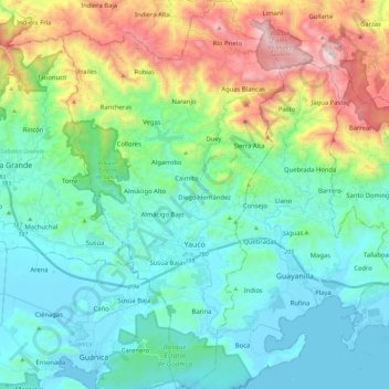
Name: Yauco topographic map, elevation, terrain.
Location: Yauco, Puerto Rico, United States (17.95473 -66.92651 18.17129 -66.79606)
Average elevation: 297 m
Minimum elevation: -1 m
Maximum elevation: 1,163 m
Thank you for supporting this site ❤️
Make a donation
Make a donation
Other topographic maps
Click on a map to view its topography, its elevation and its terrain.