
Thank you for supporting this site ❤️
Make a donation
Make a donation
Seward topographic map
Click on the map to display elevation.
Thank you for supporting this site ❤️
Make a donation
Make a donation
About this map
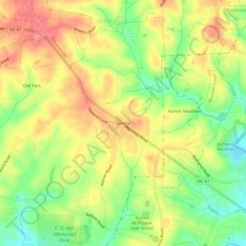
Name: Seward topographic map, elevation, terrain.
Location: Seward, Forsyth County, North Carolina, 27040, United States (36.16653 -80.38922 36.20653 -80.34922)
Average elevation: 272 m
Minimum elevation: 232 m
Maximum elevation: 307 m
Thank you for supporting this site ❤️
Make a donation
Make a donation
Other topographic maps
Click on a map to view its topography, its elevation and its terrain.
Salem Lake
United States > North Carolina > Forsyth County > Winston-Salem > Woodbridge
Average elevation: 264 m
Salem Creek
United States > North Carolina > Forsyth County > Winston-Salem > Salem
Average elevation: 251 m