
Make a donation
Tracy topographic map
Click on the map to display elevation.
Make a donation
About this map
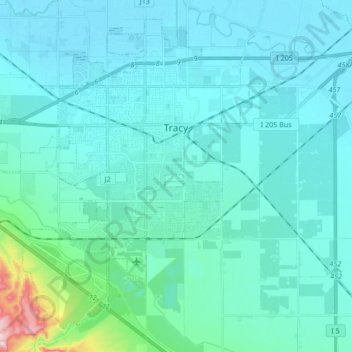
Name: Tracy topographic map, elevation, terrain.
Location: Tracy, San Joaquin County, California, United States (37.66056 -121.54902 37.77961 -121.38010)
Average elevation: 35 m
Minimum elevation: -2 m
Maximum elevation: 330 m
Make a donation
Other topographic maps
Click on a map to view its topography, its elevation and its terrain.
Lathrop
United States > California > San Joaquin County > Lathrop > Lathrop
Lathrop is located at 37°49′1″N 121°17′19″W / 37.81694°N 121.28861°W / 37.81694; -121.28861 (37.816904, -121.288633). The San Joaquin River is on the west side of Lathrop and has elevation of 20 feet (7 m).
Average elevation: 7 m
Make a donation
Mountain House
United States > California > San Joaquin County
Mountain House lies on the foothills of the Diablo Range, and close to the Altamont Pass which is over 1,000 feet in elevation. It is on the border of Alameda and Contra Costa counties. According to the United States Census Bureau, the CDP covers an area of 3.2 square miles (8.3 km2), all of it land. The…
Average elevation: 22 m
Make a donation
The Homestead
United States > California > San Joaquin County > Stockton > The Homestead
Average elevation: 6 m
Peters
United States > California > San Joaquin County > Peters
Peters is a census-designated place in San Joaquin County, California. Peters sits at an elevation of 112 feet (34 m). The 2010 United States census reported Peters' population was 672.
Average elevation: 32 m
Make a donation