
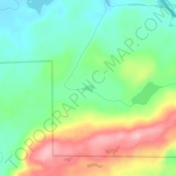
Ernest Lake topographic map
Interactive map
Click on the map to display elevation.
About this map
Name: Ernest Lake topographic map, elevation, terrain.
Average elevation: 505 m
Minimum elevation: 444 m
Maximum elevation: 602 m
Other topographic maps
Click on a map to view its topography, its elevation and its terrain.
Eagle Mountain
United States > Minnesota > Cook County
Eagle Mountain, West Cook, Cook County, Minnesota, United States
Average elevation: 596 m
Sea Gull Lake
United States > Minnesota > Cook County
Sea Gull Lake, West Cook, Cook County, Minnesota, United States
Average elevation: 460 m
Marshall Lake
United States > Minnesota > Cook County
Marshall Lake, West Cook, Cook County, Minnesota, United States
Average elevation: 556 m
Cream Lake
United States > Minnesota > Cook County
Cream Lake, West Cook, Cook County, Minnesota, United States
Average elevation: 574 m
George Lake
United States > Minnesota > Cook County
George Lake, West Cook, Cook County, Minnesota, United States
Average elevation: 551 m
Bull Lake
United States > Minnesota > Cook County
Bull Lake, West Cook, Cook County, Minnesota, United States
Average elevation: 571 m
Jimmy Lake
United States > Minnesota > Cook County
Jimmy Lake, West Cook, Cook County, Minnesota, United States
Average elevation: 489 m
Benson Lake
United States > Minnesota > Cook County
Benson Lake, East Cook, Cook County, Minnesota, United States
Average elevation: 505 m
Tofte
United States > Minnesota > Cook County > Tofte
Tofte, Cook County, Minnesota, 55613, United States
Average elevation: 223 m
Kingfisher Lake
United States > Minnesota > Cook County
Kingfisher Lake, Cook County, Minnesota, United States
Average elevation: 464 m
Smoke Lake
United States > Minnesota > Cook County
Smoke Lake, Cook County, Minnesota, United States
Average elevation: 557 m
Axe Lake
United States > Minnesota > Cook County
Axe Lake, Cook County, Minnesota, United States
Average elevation: 565 m
Grand Marais
United States > Minnesota > Cook County
Grand Marais, Cook County, Minnesota, United States
Average elevation: 280 m