
Thank you for supporting this site ❤️
Make a donation
Make a donation
Hill Haven topographic map
Click on the map to display elevation.
Thank you for supporting this site ❤️
Make a donation
Make a donation
About this map
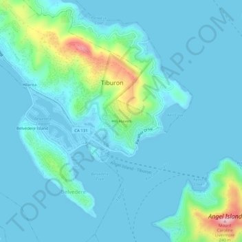
Name: Hill Haven topographic map, elevation, terrain.
Average elevation: 31 m
Minimum elevation: -4 m
Maximum elevation: 227 m
Thank you for supporting this site ❤️
Make a donation
Make a donation
Other topographic maps
Click on a map to view its topography, its elevation and its terrain.
Old Saint Hilary's Open Space Preserve
United States > California > Marin County > Tiburon > Hill Haven
Average elevation: 42 m