
Denver topographic map
Click on the map to display elevation.
About this map
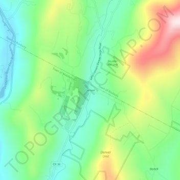
Name: Denver topographic map, elevation, terrain.
Average elevation: 594 m
Minimum elevation: 420 m
Maximum elevation: 919 m
Other topographic maps
Click on a map to view its topography, its elevation and its terrain.
Bear Spring Mountain Wildlife Management Area
United States > New York > Delaware County > Town of Hancock
Average elevation: 619 m
Town of Bovina
United States > New York > Delaware County
The town has some of the highest uplands in the county. The elevation of the highest point exceeds 3,340 feet (1,020 m) above sea level, on an unnamed summit at the eastern corner of the town overlooking the Plattekill Mountain ski area in neighboring Roxbury.
Average elevation: 670 m
New Kingston Mountain Unit
United States > New York > Delaware County > Town of Roxbury
Average elevation: 699 m