
Пирот topographic map
Interactive map
Click on the map to display elevation.
About this map
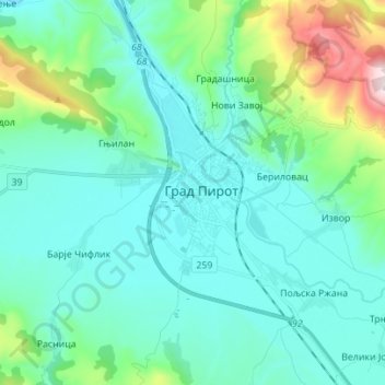
Name: Пирот topographic map, elevation, terrain.
Average elevation: 483 m
Minimum elevation: 340 m
Maximum elevation: 1,148 m
Other topographic maps
Click on a map to view its topography, its elevation and its terrain.
Миџор / Миджур
Serbie > Serbie centrale > Пиротски управни округ > Град Пирот
Миџор / Миджур, Град Пирот, Пиротски управни округ, Serbie centrale, Serbie
Average elevation: 1,810 m