
Durmitor topographic map
Interactive map
Click on the map to display elevation.
About this map
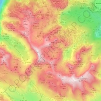
Name: Durmitor topographic map, elevation, terrain.
Location: Durmitor, Žabljak Municipality, 84220, Montenegro (43.11351 18.99953 43.15118 19.08860)
Average elevation: 1,953 m
Minimum elevation: 1,390 m
Maximum elevation: 2,463 m
Other topographic maps
Click on a map to view its topography, its elevation and its terrain.
Dubrovnik
Montenegro > Plužine Municipality
Dubrovnik, Plužine Municipality, Montenegro
Average elevation: 1,720 m