
Thank you for supporting this site ❤️
Make a donation
Make a donation
Burladingen topographic map
Click on the map to display elevation.
Thank you for supporting this site ❤️
Make a donation
Make a donation
Burladingen
The township (Stadt) of Burladingen is located in the Swabian Jura, specifically where the Middle Kuppenalb [de] transitions into the western Jura. Elevation above sea level in the municipal area varies from a low of 611 meters (2,005 ft) Normalnull (NN) to a high of 933 meters (3,061 ft).
Thank you for supporting this site ❤️
Make a donation
Make a donation
About this map
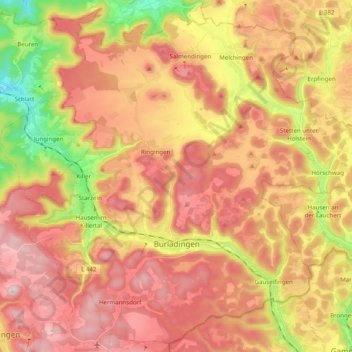
Name: Burladingen topographic map, elevation, terrain.
Location: Burladingen, Zollernalbkreis, Baden-Württemberg, 72393, Germany (48.25209 9.02464 48.37667 9.22166)
Average elevation: 784 m
Minimum elevation: 531 m
Maximum elevation: 970 m
Thank you for supporting this site ❤️
Make a donation
Make a donation
Other topographic maps
Click on a map to view its topography, its elevation and its terrain.