
Thank you for supporting this site ❤️
Make a donation
Make a donation
Bangui topographic map
Click on the map to display elevation.
Thank you for supporting this site ❤️
Make a donation
Make a donation
About this map
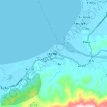
Name: Bangui topographic map, elevation, terrain.
Location: Bangui, Ilocos Norte, Ilocos Region, 2920, Philippines (18.49674 120.72576 18.57674 120.80576)
Average elevation: 72 m
Minimum elevation: -1 m
Maximum elevation: 813 m
Thank you for supporting this site ❤️
Make a donation
Make a donation
Other topographic maps
Click on a map to view its topography, its elevation and its terrain.