
Make a donation
Sandy Ridge topographic map
Click on the map to display elevation.
Make a donation
Sandy Ridge
Sandy Ridge is located in Pennsylvania, at 40°48′43″N 78°13′56″W / 40.81194°N 78.23222°W / 40.81194; -78.23222 (40.811904, -78.232142), southwest of the center of Rush Township. It sits at an elevation of 1,800 to 1,950 feet (550 to 590 m), 3 miles (5 km) northwest of the physical Sandy Ridge, the 2,500-foot-high (760 m) local expression of the Allegheny Front.
Make a donation
About this map
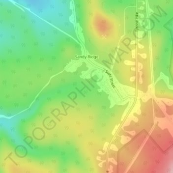
Name: Sandy Ridge topographic map, elevation, terrain.
Average elevation: 576 m
Minimum elevation: 498 m
Maximum elevation: 667 m
Make a donation
Other topographic maps
Click on a map to view its topography, its elevation and its terrain.
Make a donation
Make a donation
The Arboretum at Penn State
United States > Pennsylvania > Centre County > Krumrine
Average elevation: 353 m
Make a donation
Park Hills Park
United States > Pennsylvania > Centre County > State College > Park Forest Village
Average elevation: 377 m