
Make a donation
Joppa topographic map
Click on the map to display elevation.
Make a donation
About this map
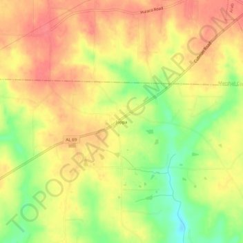
Name: Joppa topographic map, elevation, terrain.
Location: Joppa, Cullman County, Alabama, 35087, United States (34.27787 -86.57610 34.31787 -86.53610)
Average elevation: 308 m
Minimum elevation: 267 m
Maximum elevation: 334 m
Make a donation
Other topographic maps
Click on a map to view its topography, its elevation and its terrain.
Holly Pond
United States > Alabama > Cullman County
Holly Pond is located in eastern Cullman County at 34°10′29″N 86°37′1″W / 34.17472°N 86.61694°W / 34.17472; -86.61694 (34.174657, -86.617004). The town is concentrated around the intersection of U.S. Route 278 and State Route 91. The elevation at the center of town is approximately 870…
Average elevation: 249 m
Make a donation
Dodge City
United States > Alabama > Cullman County
The elevation is 628 feet (191 m) above sea level.
Average elevation: 192 m
Cullman
United States > Alabama > Cullman County
Cullman is located on top of the Brindley Mountain plateau at 34°10′39″N 86°50′42″W / 34.17750°N 86.84500°W / 34.17750; -86.84500 (34.177508, −86.844996). This is a close offshoot of the long geographic ridge called Sand Mountain, a southmost extension of the Appalachian Mountains. The…
Average elevation: 239 m
Make a donation