
Thank you for supporting this site ❤️
Make a donation
Make a donation
Leona topographic map
Click on the map to display elevation.
Thank you for supporting this site ❤️
Make a donation
Make a donation
About this map
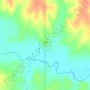
Name: Leona topographic map, elevation, terrain.
Location: Leona, Doniphan County, Kansas, United States (39.78403 -95.32377 39.78880 -95.31938)
Average elevation: 293 m
Minimum elevation: 276 m
Maximum elevation: 321 m
Thank you for supporting this site ❤️
Make a donation
Make a donation
Other topographic maps
Click on a map to view its topography, its elevation and its terrain.