
Aigües Tòrtes topographic map
Interactive map
Click on the map to display elevation.
About this map
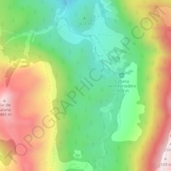
Name: Aigües Tòrtes topographic map, elevation, terrain.
Location: Aigües Tòrtes, Naut Aran, Val d'Aran, Catalonië, 25539, Spanje (42.63924 0.91585 42.65924 0.93585)
Average elevation: 2,015 m
Minimum elevation: 1,669 m
Maximum elevation: 2,492 m
Other topographic maps
Click on a map to view its topography, its elevation and its terrain.
Baqueira
Spanje > Catalonië > Val d'Aran
Baqueira, Naut Aran, Val d'Aran, Lerida, Catalonië, 25539, Spanje
Average elevation: 1,704 m
Val d'Aran
Spanje > Catalonië > Val d'Aran
Val d'Aran, Lerida, Catalonië, Spanje
Average elevation: 1,899 m
Vilac
Spanje > Catalonië > Val d'Aran > Vielha e Mijaran > Vilac
Vilac, Vielha e Mijaran, Val d'Aran, Lerida, Catalonië, 25530, Spanje
Average elevation: 1,328 m