
Thank you for supporting this site ❤️
Make a donation
Make a donation
Desert Mountain topographic map
Click on the map to display elevation.
Thank you for supporting this site ❤️
Make a donation
Make a donation
About this map
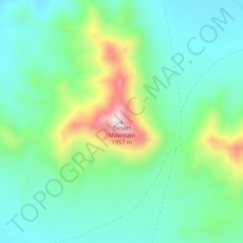
Name: Desert Mountain topographic map, elevation, terrain.
Location: Desert Mountain, Juab County, Utah, United States (39.78129 -112.59417 39.78139 -112.59407)
Average elevation: 1,673 m
Minimum elevation: 1,563 m
Maximum elevation: 1,953 m
Thank you for supporting this site ❤️
Make a donation
Make a donation
Other topographic maps
Click on a map to view its topography, its elevation and its terrain.
Eureka
United States > Utah > Juab County
Eureka is located in northern Juab County at 39°57′18″N 112°6′59″W / 39.95500°N 112.11639°W / 39.95500; -112.11639 (39.954974, -112.116364). It sits in the East Tintic Mountains at an elevation of 6,430 feet (1,960 m) above sea level. The northeast boundary of the city is the Utah County…
Average elevation: 2,048 m