McKenzie River topographic map
Interactive map
Click on the map to display elevation.
About this map
![McKenzie River topographic map, elevation, terrain](/pub/maps/relation/8wmt/x85hgp/thumbnail.jpg)
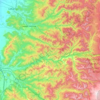
Name: McKenzie River topographic map, elevation, terrain.
Location: McKenzie River, Lane County, Oregon, United States (44.05292 -123.10739 44.36102 -121.99422)
Average elevation: 698 m
Minimum elevation: 76 m
Maximum elevation: 2,025 m
The McKenzie River drains a region of about 1,300 square miles (3,400 km2) and is one of the primary tributaries of the Willamette River. Elevations in the watershed range from 10,358 feet (3,157 m) at the summit of the South Sister to 375 feet (114 m) at the McKenzie's mouth on the Willamette River north of Eugene. The upper basin, in the high Cascades, consists of granular, permeable igneous rocks that are geologically young, while most of the middle and lower McKenzie valley in the Western Cascades is made of the remnants of older, more weathered volcanic rocks. Major watersheds bordering the McKenzie basin include the Calapooia; the South, Middle and North Santiam rivers to the north; the Middle Fork Willamette River to the south; and the Deschutes River to the east.
Other topographic maps
Click on a map to view its topography, its elevation and its terrain.
![Eugene topographic map, elevation, terrain](/pub/maps/relation/5657/s5tmt/icon.jpg)
Eugene
United States > Oregon > Lane County
Eugene, Lane County, Oregon, United States
Average elevation: 163 m
![Florence topographic map, elevation, terrain](/pub/maps/relation/v5tj/j4k5k/icon.jpg)
Florence
United States > Oregon > Lane County
Florence, Lane County, Oregon, United States
Average elevation: 22 m
![Mabel topographic map, elevation, terrain](/pub/maps/node/wd18/l69hctp/icon.jpg)
Mabel
United States > Oregon > Lane County
Mabel, Lane County, Oregon, 97454, United States
Average elevation: 257 m
![Cheshire topographic map, elevation, terrain](/pub/maps/node/z13q/3f79xdn/icon.jpg)
Cheshire
United States > Oregon > Lane County > Cheshire
Cheshire, Lane County, Oregon, 97419, United States
Average elevation: 109 m
![Pleasant Hill topographic map, elevation, terrain](/pub/maps/node/82m2/9g56p4s/icon.jpg)
Pleasant Hill
United States > Oregon > Lane County
Pleasant Hill, Lane County, Oregon, 97455, United States
Average elevation: 183 m
![Leaburg topographic map, elevation, terrain](/pub/maps/node/t9tj/3f76sdn/icon.jpg)
Leaburg
United States > Oregon > Lane County
Leaburg, Lane County, Oregon, United States
Average elevation: 355 m
![Mapleton topographic map, elevation, terrain](/pub/maps/node/rccz/43lg9m2/icon.jpg)
Mapleton
United States > Oregon > Lane County
Mapleton, Lane County, Oregon, 97453, United States
Average elevation: 131 m
![McKenzie River topographic map, elevation, terrain](/pub/maps/way/5ct6/r8fk33l/icon.jpg)
McKenzie River
United States > Oregon > Lane County > Rainbow
McKenzie River, Rainbow, Lane County, Oregon, 97413, United States
Average elevation: 431 m
![Dorena Lake topographic map, elevation, terrain](/pub/maps/relation/xms8/9mgg1h/icon.jpg)
Dorena Lake
United States > Oregon > Lane County
Dorena Lake, Lane County, Oregon, United States
Average elevation: 331 m
![Cheshire topographic map, elevation, terrain](/pub/maps/way/g3tf/37t83rs8/icon.jpg)
Cheshire
United States > Oregon > Lane County
Cheshire, Lane County, Oregon, United States
Average elevation: 109 m
![Oakridge topographic map, elevation, terrain](/pub/maps/relation/dhz4/ljpgp/icon.jpg)
Oakridge
United States > Oregon > Lane County
Oakridge, Lane County, Oregon, United States
Average elevation: 465 m
![Waldo Lake Wilderness topographic map, elevation, terrain](/pub/maps/relation/d51h/477vrr/icon.jpg)
Waldo Lake Wilderness
United States > Oregon > Lane County
Waldo Lake Wilderness, Lane County, Oregon, United States
Average elevation: 1,528 m
![Cottage Grove topographic map, elevation, terrain](/pub/maps/relation/lntp/9234s/icon.jpg)
Cottage Grove
United States > Oregon > Lane County
Cottage Grove, Lane County, Oregon, 97424, United States
Average elevation: 230 m
![Coburg topographic map, elevation, terrain](/pub/maps/relation/x33l/fjp1h/icon.jpg)
Coburg
United States > Oregon > Lane County
Coburg, Lane County, Oregon, 97408, United States
Average elevation: 120 m
![Swisshome topographic map, elevation, terrain](/pub/maps/node/f718/dkwfr14/icon.jpg)
Swisshome
United States > Oregon > Lane County
Swisshome, Lane County, Oregon, 97480, United States
Average elevation: 222 m
![Veneta topographic map, elevation, terrain](/pub/maps/relation/fp1h/7r818/icon.jpg)
Veneta
United States > Oregon > Lane County
Veneta, Lane County, Oregon, 97487, United States
Average elevation: 133 m
![Westfir topographic map, elevation, terrain](/pub/maps/relation/934s/mw151/icon.jpg)
Westfir
United States > Oregon > Lane County
Westfir, Lane County, Oregon, 47492, United States
Average elevation: 442 m
![Disston topographic map, elevation, terrain](/pub/maps/node/xrzs/kwbdbf3/icon.jpg)
Disston
United States > Oregon > Lane County
Disston, Lane County, Oregon, United States
Average elevation: 512 m
![Lowell topographic map, elevation, terrain](/pub/maps/relation/sngt/n6q3q/icon.jpg)
Lowell
United States > Oregon > Lane County
Lowell, Lane County, Oregon, 97452, United States
Average elevation: 261 m
![Marcola topographic map, elevation, terrain](/pub/maps/node/cknx/w5qlrtf/icon.jpg)
Marcola
United States > Oregon > Lane County
Marcola, Lane County, Oregon, United States
Average elevation: 223 m
![Elmira topographic map, elevation, terrain](/pub/maps/way/55kl/9wnswg5k/icon.jpg)
Elmira
United States > Oregon > Lane County > Elmira
Elmira, Lane County, Oregon, United States
Average elevation: 120 m
![Washington/Jefferson City Park topographic map, elevation, terrain](/pub/maps/way/4hmt/b86dttf/icon.jpg)
Washington/Jefferson City Park
United States > Oregon > Lane County > Eugene
Washington/Jefferson City Park, Eugene, Lane County, Oregon, United States
Average elevation: 130 m
![Rainbow topographic map, elevation, terrain](/pub/maps/node/zw5k/43fskm2/icon.jpg)
Rainbow
United States > Oregon > Lane County
Rainbow, Lane County, Oregon, 97413, United States
Average elevation: 486 m
![Noti topographic map, elevation, terrain](/pub/maps/node/s8z4/d8f9tmgp/icon.jpg)
Noti
United States > Oregon > Lane County > Noti
Noti, Lane County, Oregon, 97461, United States
Average elevation: 201 m
![West Bank City Park topographic map, elevation, terrain](/pub/maps/way/51kl/5mqp2tj/icon.jpg)
West Bank City Park
United States > Oregon > Lane County > Eugene
West Bank City Park, Bethel, Eugene, Lane County, Oregon, United States
Average elevation: 125 m
![Springfield topographic map, elevation, terrain](/pub/maps/relation/m251/dz4z4/icon.jpg)
Springfield
United States > Oregon > Lane County
Springfield, Lane County, Oregon, United States
Average elevation: 177 m
![Walton topographic map, elevation, terrain](/pub/maps/node/7p9m/xbj7n3l/icon.jpg)
Walton
United States > Oregon > Lane County
Walton, Lane County, Oregon, United States
Average elevation: 231 m
![Cupit Mary Mountain topographic map, elevation, terrain](/pub/maps/node/731h/fm14s3q/icon.jpg)
Cupit Mary Mountain
United States > Oregon > Lane County
Cupit Mary Mountain, Lane County, Oregon, United States
Average elevation: 1,702 m
![Dorena topographic map, elevation, terrain](/pub/maps/node/vkrr/mslk751/icon.jpg)
Dorena
United States > Oregon > Lane County > Dorena
Dorena, Lane County, Oregon, 97434, United States
Average elevation: 434 m
![Culp Creek topographic map, elevation, terrain](/pub/maps/node/qbnx/jcr495k/icon.jpg)
Culp Creek
United States > Oregon > Lane County > Culp Creek
Culp Creek, Lane County, Oregon, 97434, United States
Average elevation: 474 m
![Saddle Camp Butte topographic map, elevation, terrain](/pub/maps/node/wft6/cb627f3/icon.jpg)
Saddle Camp Butte
United States > Oregon > Lane County
Saddle Camp Butte, Lane County, Oregon, United States
Average elevation: 973 m
![Junction City topographic map, elevation, terrain](/pub/maps/relation/649m/5h757/icon.jpg)
Junction City
United States > Oregon > Lane County
Junction City, Lane County, Oregon, United States
Average elevation: 102 m
![McKenzie Bridge topographic map, elevation, terrain](/pub/maps/node/xttf/43lv6m2/icon.jpg)
McKenzie Bridge
United States > Oregon > Lane County
McKenzie Bridge, Lane County, Oregon, 97413, United States
Average elevation: 521 m
![Waldo Lake topographic map, elevation, terrain](/pub/maps/relation/g57/lbmkb3/icon.jpg)
Waldo Lake
United States > Oregon > Lane County
Waldo Lake, Lane County, Oregon, United States
Average elevation: 1,687 m
![Creswell topographic map, elevation, terrain](/pub/maps/relation/tqcz/x1s3l/icon.jpg)
Creswell
United States > Oregon > Lane County
Creswell, Lane County, Oregon, 97426, United States
Average elevation: 165 m
![Mount Popocatepetl topographic map, elevation, terrain](/pub/maps/node/m6mt/ncwntt6/icon.jpg)
Mount Popocatepetl
United States > Oregon > Lane County
Mount Popocatepetl, Lane County, Oregon, United States
Average elevation: 163 m