
Thank you for supporting this site ❤️
Make a donation
Make a donation
Lake Merwin topographic map
Click on the map to display elevation.
Thank you for supporting this site ❤️
Make a donation
Make a donation
About this map
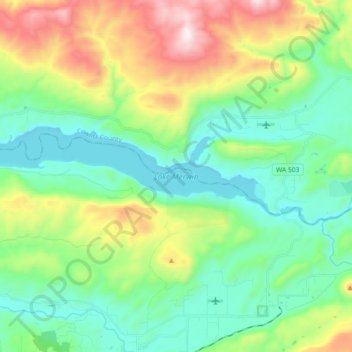
Name: Lake Merwin topographic map, elevation, terrain.
Location: Lake Merwin, Clark County, Washington, United States (45.95610 -122.56028 45.99213 -122.37901)
Average elevation: 323 m
Minimum elevation: 58 m
Maximum elevation: 958 m
Thank you for supporting this site ❤️
Make a donation
Make a donation
Other topographic maps
Click on a map to view its topography, its elevation and its terrain.
Thank you for supporting this site ❤️
Make a donation
Make a donation
Thank you for supporting this site ❤️
Make a donation
Make a donation