
Make a donation
El Tablón topographic map
Click on the map to display elevation.
Make a donation
About this map
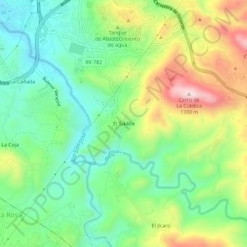
Name: El Tablón topographic map, elevation, terrain.
Average elevation: 1,115 m
Minimum elevation: 967 m
Maximum elevation: 1,371 m
Make a donation
Other topographic maps
Click on a map to view its topography, its elevation and its terrain.
Barrio El Calvario
Honduras > Francisco Morazán > Distrito Central > Tegucigalpa
Average elevation: 964 m
Colonia Residencial Santa Cruz
Honduras > Francisco Morazán > Distrito Central > Tegucigalpa
Average elevation: 1,133 m
Colonia San Juan Bosco
Honduras > Francisco Morazán > Distrito Central > Tegucigalpa
Average elevation: 1,184 m
Parque El Trapiche
Honduras > Francisco Morazán > Distrito Central > Tegucigalpa
Average elevation: 1,041 m
Make a donation
Colonia Los Ángeles
Honduras > Francisco Morazán > Distrito Central > Tegucigalpa
Average elevation: 1,041 m
Represa Los Laureles
Honduras > Francisco Morazán > Distrito Central > Tegucigalpa
Average elevation: 1,063 m
Rio Grande o Choluteca
Honduras > Francisco Morazán > Distrito Central > Tegucigalpa > Comayagüela
Average elevation: 967 m
Make a donation