
Thank you for supporting this site ❤️
Make a donation
Make a donation
Union Ridge topographic map
Click on the map to display elevation.
Thank you for supporting this site ❤️
Make a donation
Make a donation
About this map
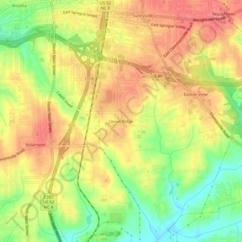
Name: Union Ridge topographic map, elevation, terrain.
Average elevation: 262 m
Minimum elevation: 223 m
Maximum elevation: 290 m
Thank you for supporting this site ❤️
Make a donation
Make a donation
Other topographic maps
Click on a map to view its topography, its elevation and its terrain.
Salem Lake
United States > North Carolina > Forsyth County > Winston-Salem > Woodbridge
Average elevation: 264 m
Salem Creek
United States > North Carolina > Forsyth County > Winston-Salem > Salem
Average elevation: 251 m