
Thank you for supporting this site ❤️
Make a donation
Make a donation
Cuyamapa topographic map
Click on the map to display elevation.
Thank you for supporting this site ❤️
Make a donation
Make a donation
About this map
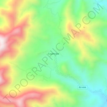
Name: Cuyamapa topographic map, elevation, terrain.
Location: Cuyamapa, Danlí, El Paraíso, Honduras (14.24023 -86.36048 14.28023 -86.32048)
Average elevation: 997 m
Minimum elevation: 667 m
Maximum elevation: 1,455 m
Thank you for supporting this site ❤️
Make a donation
Make a donation
Other topographic maps
Click on a map to view its topography, its elevation and its terrain.