
Thank you for supporting this site ❤️
Make a donation
Make a donation
Cemoro Lawang topographic map
Click on the map to display elevation.
Thank you for supporting this site ❤️
Make a donation
Make a donation
About this map
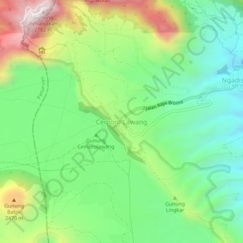
Name: Cemoro Lawang topographic map, elevation, terrain.
Location: Cemoro Lawang, Probolinggo, East Java, Indonesia (-7.94186 112.94516 -7.90186 112.98516)
Average elevation: 2,171 m
Minimum elevation: 1,856 m
Maximum elevation: 2,749 m
Thank you for supporting this site ❤️
Make a donation
Make a donation