
Dietkirchen topographic map
Interactive map
Click on the map to display elevation.
About this map
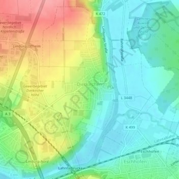
Name: Dietkirchen topographic map, elevation, terrain.
Average elevation: 144 m
Minimum elevation: 108 m
Maximum elevation: 207 m
Other topographic maps
Click on a map to view its topography, its elevation and its terrain.
Lindenholzhausen
Deutschland > Hessen > Landkreis Limburg-Weilburg > Limburg an der Lahn
Lindenholzhausen, Limburg an der Lahn, Landkreis Limburg-Weilburg, Hessen, 65551, Deutschland
Average elevation: 171 m
Staffel
Deutschland > Hessen > Landkreis Limburg-Weilburg > Limburg an der Lahn
Staffel, Limburg an der Lahn, Landkreis Limburg-Weilburg, Hessen, 65556, Deutschland
Average elevation: 126 m
Eschhofen
Deutschland > Hessen > Landkreis Limburg-Weilburg > Limburg an der Lahn
Eschhofen, Limburg an der Lahn, Landkreis Limburg-Weilburg, Hessen, 65552, Deutschland
Average elevation: 148 m
Ahlbach
Deutschland > Hessen > Landkreis Limburg-Weilburg > Limburg an der Lahn
Ahlbach, Limburg an der Lahn, Landkreis Limburg-Weilburg, Hessen, 65554, Deutschland
Average elevation: 194 m