
Thank you for supporting this site ❤️
Make a donation
Make a donation
East Meadow topographic map
Click on the map to display elevation.
Thank you for supporting this site ❤️
Make a donation
Make a donation
East Meadow
East Meadow is generally flat, and according to the United States Geological Survey and the United States Environmental Protection Agency, the elevation ranges from 32 feet (9.8 m) near its southwestern edge, to 82 feet (25 m) along Hempstead Turnpike to the north.
Thank you for supporting this site ❤️
Make a donation
Make a donation
About this map
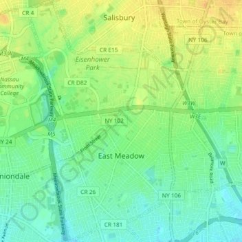
Name: East Meadow topographic map, elevation, terrain.
Average elevation: 26 m
Minimum elevation: 14 m
Maximum elevation: 41 m
Thank you for supporting this site ❤️
Make a donation
Make a donation