
Thank you for supporting this site ❤️
Make a donation
Make a donation
Edgecomb topographic map
Click on the map to display elevation.
Thank you for supporting this site ❤️
Make a donation
Make a donation
About this map
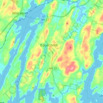
Name: Edgecomb topographic map, elevation, terrain.
Location: Edgecomb, Lincoln County, Maine, United States (43.92231 -69.67673 44.01712 -69.56296)
Average elevation: 25 m
Minimum elevation: -3 m
Maximum elevation: 96 m
Thank you for supporting this site ❤️
Make a donation
Make a donation
Other topographic maps
Click on a map to view its topography, its elevation and its terrain.