Lower Hutt topographic map
Click on the map to display elevation.
About this map

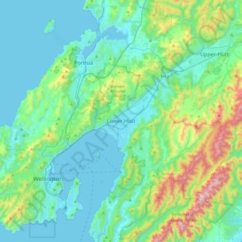
Name: Lower Hutt topographic map, elevation, terrain.
Location: Lower Hutt, Lower Hutt City, Wellington, 5040, New Zealand (-41.37258 174.74576 -41.05258 175.06576)
Average elevation: 173 m
Minimum elevation: 0 m
Maximum elevation: 907 m
Other topographic maps
Click on a map to view its topography, its elevation and its terrain.

Wainuiomata River
New Zealand > Wellington > Lower Hutt City
Wainuiomata River, Lower Hutt City, Wellington, New Zealand
Average elevation: 181 m

Hutt Valley
New Zealand > Wellington > Lower Hutt City > Lower Hutt
Hutt Valley, Lower Hutt, Lower Hutt City, Wellington, New Zealand
Average elevation: 212 m

Waimarama
New Zealand > Wellington > Lower Hutt City
Waimarama, Lower Hutt City, Wellington, New Zealand
Average elevation: 213 m

Ōrongorongo River
New Zealand > Wellington > Lower Hutt City
Ōrongorongo River, Lower Hutt City, Wellington, New Zealand
Average elevation: 237 m