
Western Area topographic map
Interactive map
Click on the map to display elevation.
About this map
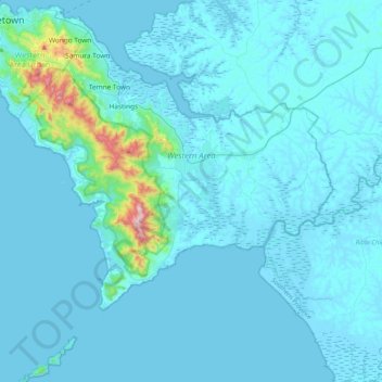
Name: Western Area topographic map, elevation, terrain.
Location: Western Area, Sierra Leone (8.09303 -13.29851 8.49962 -12.91369)
Average elevation: 49 m
Minimum elevation: -4 m
Maximum elevation: 870 m
Other topographic maps
Click on a map to view its topography, its elevation and its terrain.
Waima
Waima, Bo District, Southern Province, Sierra Leone, Sierra Leone
Average elevation: 47 m
Waterloo
Sierra Leone > Western Area > Waterloo
Waterloo, Western Area Rural, Western Area, Sierra Leone
Average elevation: 70 m
Sherbro Island
Sierra Leone > Southern Province
Sherbro Island, Bonthe District, Southern Province, Sierra Leone
Average elevation: 3 m
Moa
Sierra Leone > Eastern Province
Moa, Kailahun District, Eastern Province, Sierra Leone
Average elevation: 165 m