
Make a donation
Eastern Province topographic map
Click on the map to display elevation.
Make a donation
About this map
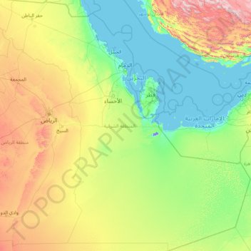
Name: Eastern Province topographic map, elevation, terrain.
Location: Eastern Province, Saudi Arabia (19.00050 44.64599 29.15925 55.66669)
Average elevation: 329 m
Minimum elevation: -14 m
Maximum elevation: 2,962 m
Make a donation
Other topographic maps
Click on a map to view its topography, its elevation and its terrain.
Abha
Abha is located in the southern region of Asir at an elevation of about 2,270 metres (7,450 feet) above sea level. Abha lies on the western edge of Mount Al-Hijaz, near Jabal Sawda, the highest peak in Saudi Arabia. Treating the Asir Mountains as part of the Sarawat, the landscape is otherwise dominated by the…
Average elevation: 1,994 m
Bishah
Bisha (Arabic: بيشة, Bīšah), also known as Qal`at Bishah (Arabic: قلعة بيشة, Qalʿat Bīšah), is a town in the south-western Saudi Arabian province, 'Asir. Bisha was its own province before merging with its neighboring province, 'Asir. Bisha has a population of 202,096 according to the 2022…
Average elevation: 1,194 m
Make a donation