
Snow Creek Glacier topographic map
Interactive map
Click on the map to display elevation.
About this map
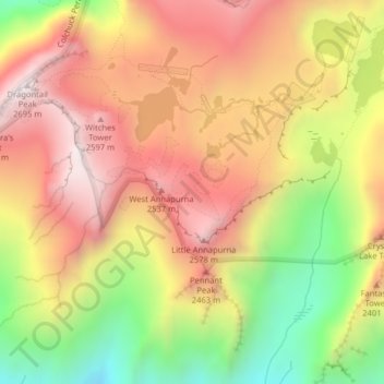
Name: Snow Creek Glacier topographic map, elevation, terrain.
Average elevation: 2,225 m
Minimum elevation: 1,667 m
Maximum elevation: 2,662 m
Other topographic maps
Click on a map to view its topography, its elevation and its terrain.
Lake Sutherland
USA > Washington > Snug Harbor
Lake Sutherland, Yew Tree Drive, Snug Harbor, Clallam County, Washington, USA
Average elevation: 295 m
Tukwila
USA > Washington > Tukwila
Tukwila, King County, Washington, 98188, USA
Average elevation: 59 m
Olympic Mountains
Olympic Mountains, Jefferson County, Washington, 98305, USA
Average elevation: 511 m
Challenger Glacier
Challenger Glacier, Little Beaver Trail, Whatcom County, Washington, USA
Average elevation: 1,924 m
Douglas Glacier
Douglas Glacier, North Fork Bridge Creek, Chelan County, Washington, USA
Average elevation: 2,038 m
Mount Rainier
Mount Rainier, Pierce County, Washington, USA
Average elevation: 3,938 m
Forbidden Glacier
Forbidden Glacier, Sahale Arm Trail, Skagit County, Washington, USA
Average elevation: 2,048 m
Kimtah Glacier
Kimtah Glacier, Fisher Creek Trail, Skagit County, Washington, USA
Average elevation: 1,996 m
Inspiration Glacier
Inspiration Glacier, Roush basin access trail, Skagit County, Washington, USA
Average elevation: 2,163 m
Chickamin Glacier
Chickamin Glacier, Ptarmigan Traverse, Chelan County, Washington, USA
Average elevation: 2,124 m
Talum Glaciers
Talum Glaciers, Squak Glacier Route, Whatcom County, Washington, USA
Average elevation: 2,118 m
Butterfly Glacier
Butterfly Glacier, Chelan County, Washington, USA
Average elevation: 2,121 m
Neve Glacier
USA > Washington > Diablo
Neve Glacier, Pyramid Lake Trail, Diablo, Whatcom County, Washington, USA
Average elevation: 2,074 m
Scimitar Glacier
Scimitar Glacier, Pacific Crest Trail, Snohomish County, Washington, USA
Average elevation: 2,270 m
Chocolate Glacier
Chocolate Glacier, Pacific Crest Trail, Snohomish County, Washington, USA
Average elevation: 2,469 m
Flett Glacier
Flett Glacier, Spray Park Trail, Pierce County, Washington, USA
Average elevation: 2,185 m
Sandalee Glacier
Sandalee Glacier, McGregor Trail, Chelan County, Washington, USA
Average elevation: 1,910 m
Edmunds Glacier
Edmunds Glacier, Pierce County, Washington, USA
Average elevation: 2,619 m
Upper Curtis Glacier
Upper Curtis Glacier, Sulfide Glacier Route, Whatcom County, Washington, USA
Average elevation: 2,059 m
Glacier Peak
Glacier Peak, Snohomish County, Washington, USA
Average elevation: 2,653 m
Carrie Glacier
Carrie Glacier, Bailey Range Way Trail, Jefferson County, Washington, USA
Average elevation: 1,725 m
Van Trump Glacier
USA > Washington > Paradise
Van Trump Glacier, Van Trump Trail, Paradise, Pierce County, Washington, USA
Average elevation: 2,389 m
Wyeth Glacier
Wyeth Glacier, Park Creek Trail, Skagit County, Washington, USA
Average elevation: 1,994 m
Stuart Glacier
Stuart Glacier, Horseshoe Lake Trail, Chelan County, Washington, USA
Average elevation: 2,098 m
Dusty Glacier
Dusty Glacier, Pacific Crest Trail, Snohomish County, Washington, USA
Average elevation: 2,371 m
Klawatti Glacier
Klawatti Glacier, Lucky ridge boot trail, Skagit County, Washington, USA
Average elevation: 2,001 m
Opal Lake
Opal Lake, Necklace Valley Trail, King County, Washington, USA
Average elevation: 1,677 m
Davenport Glacier
Davenport Glacier, Sahale Arm Trail, Skagit County, Washington, USA
Average elevation: 2,143 m
North Cascades National Park
North Cascades National Park, Whatcom County, Washington, USA
Average elevation: 1,151 m
Isella Glacier
USA > Washington > Holden Village
Isella Glacier, Cloudy Pass Trail #1256, Holden Village, Chelan County, Washington, USA
Average elevation: 2,258 m
Cascade Range
Cascade Range, Skamania County, Washington, USA
Average elevation: 690 m
Yawning Glacier
Yawning Glacier, Ptarmigan Traverse, Chelan County, Washington, USA
Average elevation: 1,712 m
Boston Glacier
Boston Glacier, Sahale Arm Trail, Skagit County, Washington, USA
Average elevation: 1,969 m
Katsuk Glacier
Katsuk Glacier, Fisher Creek Trail, Skagit County, Washington, USA
Average elevation: 2,007 m
Dana Glacier
Dana Glacier, Ptarmigan Traverse, Chelan County, Washington, USA
Average elevation: 2,003 m
Mount Shuksan
Mount Shuksan, Whatcom County, Washington, USA
Average elevation: 2,126 m
Hadley Glacier
Hadley Glacier, Hadley Peak Route, Whatcom County, Washington, USA
Average elevation: 1,815 m
Kennedy Glacier
Kennedy Glacier, Pacific Crest Trail, Snohomish County, Washington, USA
Average elevation: 2,538 m
Goode Glacier
Goode Glacier, North Fork Bridge Creek, Chelan County, Washington, USA
Average elevation: 1,877 m
Queets Glacier
Queets Glacier, Elwha Snowfinger Route, Jefferson County, Washington, USA
Average elevation: 1,496 m
Sherpa Glacier
Sherpa Glacier, Horseshoe Lake Trail, Chelan County, Washington, USA
Average elevation: 2,069 m
Cameron Glaciers
Cameron Glaciers, Main Fork Dosewallips River Trail, Jefferson County, Washington, USA
Average elevation: 1,796 m
Fairchild Glacier
Fairchild Glacier, Mount Carrie Way Trail, Clallam County, Washington, USA
Average elevation: 1,611 m
Quien Sabe Glacier
Quien Sabe Glacier, Sahale Arm Trail, Skagit County, Washington, USA
Average elevation: 2,143 m
Whitman Glacier
Whitman Glacier, Wonderland Trail, Pierce County, Washington, USA
Average elevation: 2,519 m