
Thank you for supporting this site ❤️
Make a donation
Make a donation
Hautapu River topographic map
Click on the map to display elevation.
Thank you for supporting this site ❤️
Make a donation
Make a donation
About this map
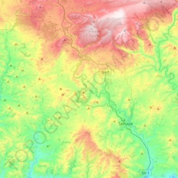
Name: Hautapu River topographic map, elevation, terrain.
Average elevation: 635 m
Minimum elevation: 305 m
Maximum elevation: 1,118 m
Rangitīkei District trails, hiking, mountain biking, running and outdoor activities
Thank you for supporting this site ❤️
Make a donation
Make a donation
Other topographic maps
Click on a map to view its topography, its elevation and its terrain.
Thank you for supporting this site ❤️
Make a donation
Make a donation
Thank you for supporting this site ❤️
Make a donation
Make a donation
Thank you for supporting this site ❤️
Make a donation
Make a donation