
Thank you for supporting this site ❤️
Make a donation
Make a donation
Lone Mountain topographic map
Click on the map to display elevation.
Thank you for supporting this site ❤️
Make a donation
Make a donation
About this map
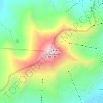
Name: Lone Mountain topographic map, elevation, terrain.
Average elevation: 2,874 m
Minimum elevation: 2,544 m
Maximum elevation: 3,400 m
Thank you for supporting this site ❤️
Make a donation
Make a donation
Other topographic maps
Click on a map to view its topography, its elevation and its terrain.
Big Sky Dam
United States > Montana > Madison County > Big Sky > Big Sky Mountain Village
Average elevation: 2,355 m