
Brčko District topographic map
Interactive map
Click on the map to display elevation.
About this map
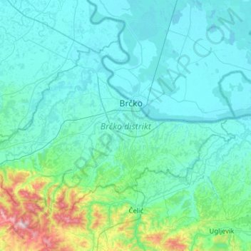
Name: Brčko District topographic map, elevation, terrain.
Location: Brčko District, Bosnia and Herzegovina (44.72033 18.50979 44.96727 19.02149)
Average elevation: 157 m
Minimum elevation: 76 m
Maximum elevation: 804 m
Other topographic maps
Click on a map to view its topography, its elevation and its terrain.
Bosanski Petrovac
Bosnia and Herzegovina > Federation of Bosnia and Herzegovina
Average elevation: 725 m
Livno
Bosnia and Herzegovina > Federation of Bosnia and Herzegovina > City of Livno
Average elevation: 907 m
Bosansko Grahovo
Bosnia and Herzegovina > Federation of Bosnia and Herzegovina
Average elevation: 931 m
Sumbulovac
Bosnia and Herzegovina > Republika Srpska > City of Istočno Sarajevo
Average elevation: 953 m
Borovica Gornja
Bosnia and Herzegovina > Federation of Bosnia and Herzegovina
Average elevation: 1,110 m
Goražde
Bosnia and Herzegovina > Federation of Bosnia and Herzegovina > City of Goražde
Average elevation: 576 m