
Thank you for supporting this site ❤️
Make a donation
Make a donation
Sumbulovac topographic map
Click on the map to display elevation.
Thank you for supporting this site ❤️
Make a donation
Make a donation
About this map
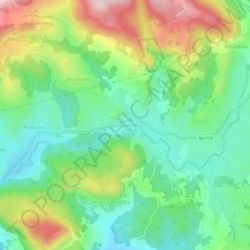
Name: Sumbulovac topographic map, elevation, terrain.
Average elevation: 953 m
Minimum elevation: 824 m
Maximum elevation: 1,184 m
Thank you for supporting this site ❤️
Make a donation
Make a donation
Other topographic maps
Click on a map to view its topography, its elevation and its terrain.
Micivode
Bosnia and Herzegovina > Republika Srpska > City of Istočno Sarajevo
Average elevation: 1,165 m
Jahorina
Bosnia and Herzegovina > Republika Srpska > City of Istočno Sarajevo
Average elevation: 1,278 m