Geolocate

Burgas topographic map

Interactive map

Click on the map to display elevation.

Burgas topographic map, elevation, terrain

Burgas topographic map, elevation, terrain

About this map

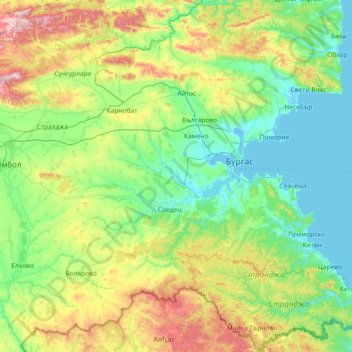
Name: Burgas topographic map, elevation, terrain.

Location: Burgas, Bulgaria (41.90441 26.57865 42.98470 28.03575)

Average elevation: 221 m

Minimum elevation: -4 m

Maximum elevation: 1,026 m

Other topographic maps

Click on a map to view its topography, its elevation and its terrain.

Vratsa

Bulgaria

Average elevation: 281 m

Skalsko

Bulgaria > Gabrovo

Average elevation: 418 m

Tetovo

Bulgaria > Ruse

Average elevation: 139 m

Vodno

Bulgaria > Silistra > Dulovo

Average elevation: 201 m

Silistra

Bulgaria > Silistra

Average elevation: 81 m

Razgrad

Bulgaria > Razgrad

Average elevation: 315 m

Haskovo

Bulgaria

Average elevation: 258 m

Blagoevgrad

Bulgaria > Blagoevgrad

Average elevation: 1,084 m

Varna

Bulgaria > Varna

Average elevation: 115 m

Golemo Buchino

Bulgaria > Golemo Buchino

Average elevation: 837 m

Vazrajdane

Bulgaria > Vazrajdane

Average elevation: 556 m

Козлодуй

Bulgaria > Козлодуй

Average elevation: 54 m

Troyan

Bulgaria > Troyan

Average elevation: 519 m

Sredna Gora

Bulgaria

Average elevation: 1,300 m

Rhodope Mountains

Bulgaria > Smolyan

Average elevation: 1,979 m

The Blue Pool

Bulgaria

Average elevation: 228 m

Lovech

Bulgaria > Lovech

Lovech is situated in the Forebalkan area of northern Bulgaria, on both sides of the river Osam, and unifies both mountainous and plain relief. The eastern part of the town is surrounded by a 250 m high plateau, where the largest park in Lovech, Stratesh, is located, and the southwestern part is surrounded by…

Average elevation: 364 m

Kostinbrod

Bulgaria

Average elevation: 731 m