
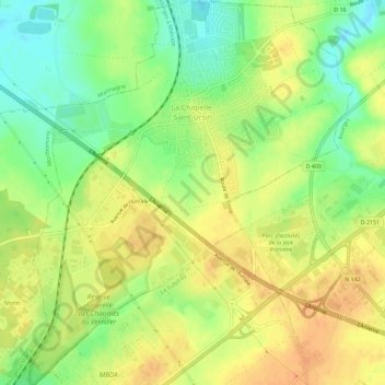
La Chapelle-Saint-Ursin topographic map
Interactive map
Click on the map to display elevation.
About this map
Name: La Chapelle-Saint-Ursin topographic map, elevation, terrain.
Average elevation: 147 m
Minimum elevation: 126 m
Maximum elevation: 163 m
Other topographic maps
Click on a map to view its topography, its elevation and its terrain.
Les Beauchots
France > Centre-Val de Loire > Cher > Assigny
Les Beauchots, Assigny, Bourges, Cher, Centre-Val de Loire, France métropolitaine, 18260, France
Average elevation: 245 m
Argent-sur-Sauldre
France > Centre-Val de Loire > Cher
Argent-sur-Sauldre, Vierzon, Cher, Centre-Val de Loire, France métropolitaine, 18410, France
Average elevation: 176 m
Sévry
France > Centre-Val de Loire > Cher
Sévry, Bourges, Cher, Centre-Val de Loire, France métropolitaine, 18140, France
Average elevation: 203 m
Vierzon
France > Centre-Val de Loire > Cher
Vierzon, Cher, Centre-Val de Loire, France métropolitaine, 18100, France
Average elevation: 137 m
Cuffy
France > Centre-Val de Loire > Cher
Cuffy, Saint-Amand-Montrond, Cher, Centre-Val de Loire, France métropolitaine, 18150, France
Average elevation: 190 m
Les Grands Bois Marteau
France > Centre-Val de Loire > Cher > Vierzon
Les Grands Bois Marteau, Vierzon, Cher, Centre-Val de Loire, France métropolitaine, 18100, France
Average elevation: 130 m
Bengy-sur-Craon
France > Centre-Val de Loire > Cher
Bengy-sur-Craon, Bourges, Cher, Centre-Val de Loire, France métropolitaine, 18520, France
Average elevation: 193 m
Jars
France > Centre-Val de Loire > Cher
Jars, Bourges, Cher, Centre-Val de Loire, France métropolitaine, 18260, France
Average elevation: 255 m
Allouis
France > Centre-Val de Loire > Cher
Allouis, Vierzon, Cher, Centre-Val de Loire, France métropolitaine, 18500, France
Average elevation: 130 m
Le Châtelet
France > Centre-Val de Loire > Cher > Le Châtelet
Le Châtelet, Saint-Amand-Montrond, Cher, Centre-Val de Loire, France métropolitaine, 18170, France
Average elevation: 231 m
Bourges
France > Centre-Val de Loire > Cher
Bourges, Cher, Centre-Val de Loire, France métropolitaine, 18000, France
Average elevation: 146 m
Sancerre
France > Centre-Val de Loire > Cher
Sancerre, Bourges, Cher, Centre-Val de Loire, France métropolitaine, 18300, France
Average elevation: 212 m