
Make a donation
Evergreen topographic map
Click on the map to display elevation.
Make a donation
Evergreen
Evergreen sits at an elevation of 7,220 feet (2,200 m) in the Rocky Mountains, 19 miles west of Denver, Colorado.
Make a donation
About this map
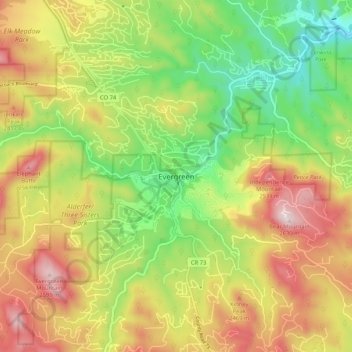
Name: Evergreen topographic map, elevation, terrain.
Average elevation: 2,301 m
Minimum elevation: 2,027 m
Maximum elevation: 2,621 m
Make a donation
Other topographic maps
Click on a map to view its topography, its elevation and its terrain.
Bear Creek Lake Park
United States > Colorado > Jefferson County > Lakewood
Average elevation: 1,741 m
Lakewood
United States > Colorado > Jefferson County > Lakewood
Lakewood is located at 39°42′17″N 105°04′53″W / 39.70472°N 105.08139°W / 39.70472; -105.08139 at an elevation of 5,518 feet (1,682 m). Located at the junction of U.S. Route 6 and Colorado State Highway 121 in central Colorado, the city lies immediately west of Denver and 62 miles (100 km)…
Average elevation: 1,717 m
Make a donation
Make a donation
Alderfer/Three Sisters Park
United States > Colorado > Jefferson County > Evergreen
Average elevation: 2,317 m
Make a donation
Make a donation