
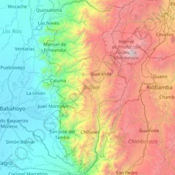
Bolívar topographic map
Interactive map
Click on the map to display elevation.
Bolívar topographic map, elevation, terrain
About this map
Name: Bolívar topographic map, elevation, terrain.
Location: Bolívar, Ecuador (-2.20312 -79.39354 -1.14980 -78.84403)
Average elevation: 1,876 m
Minimum elevation: 3 m
Maximum elevation: 6,259 m
Other topographic maps
Click on a map to view its topography, its elevation and its terrain.
Quito
Ecuador > Pichincha > Quito Canton
Quito's elevation of 2,850 m (9,350 ft) makes it either the highest or the second highest capital city in the world. This varied standing is because Bolivia is a country with multiple capitals; if La Paz is considered the Bolivian national capital, it tops the list of highest capitals, but if Sucre is…
Average elevation: 2,930 m
Sucumbíos
The western area of the province belongs to the Eastern Andes Mountains, where most rivers in the province have their sources. The most important elevation in the province is the Reventador, an active volcano. The eastern portion of the province is part of the Amazon Basin, with high temperatures.
Average elevation: 711 m
San Salvador
Ecuador > Galápagos > Cantón Santa Cruz
The city is located in the Boquerón Volcano Valley, a region of high seismic activity. The city's average elevation is 659 meters (2,162 feet) above sea level, but ranges from a highest point of 1,186 meters (3,891 feet) above sea level to a lowest point of 596 m (1,955 ft) above sea level.
Average elevation: 81 m
Santo Domingo de los Tsachilas
Ecuador > Santo Domingo de los Tsáchilas > Santo Domingo de los Tsachilas
Average elevation: 662 m